
I couldn't help, but smile and ignore the question, not because I was trying to be a smart-ass, but because I didn't have an answer. I know because I've asked myself this very thing at some point on nearly every solo trip I've done.
I've wanted to float the John Day for as long as I can remember. This spring the stars aligned for it to happen; good flow, weather in the 80's, and time off from work. I loaded my little Catboat, and two weeks of supplies into the '77 then rolled for the Blue Mountains in Eastern Oregon to begin the trip near the tiny town of Dale on the North Fork of the John Day.
Dale to Monument:

I contacted Donna's Shuttle Service in Fossil, Oregon to do my shuttle. She said that people sometimes put-in about 2 1/2 miles upstream of Hwy 395 bridge along a dirt road. I drove up there and was a bit un-nerved at the look of things. The further up canyon I drove the more technical the water became. It wasn't that bad, but there were lines that would need an "A" game at the oars of a boat overloaded with two weeks of supplies. I decided to bail on the plan to launch where Donna and I agreed that my rig would be left, hoping for the best.
The other option that I'd researched online, as a launch point, was at a place called Tollgate Campground, just upstream of the 395 bridge. I really wanted this one to work, but I saw no place to launch here. To this day, I have no idea what anyone is talking about in regards to a launch point at Tollgate. I ended up driving down the highway towards Camas Creek and found a place across the river on forest road 3963 . This one was about 2 1/2 miles down river of the 395 bridge and worked out fine. I was able to leave my truck in a clearing along the highway by the 3963 bridge where I was pretty sure that Donna would come looking for it.
It was beautiful and in the mid 80's. The water was about as cold as you'd expect snow melt to be, but I had a good time rigging the boat. I got everything rigged including a self rescue kit that would be accessible when the boat was upside down, should I flip. I parked the '77 across the bridge in clear view of the highway with a decent tip and a note of apology under the floor mat. I pushed off and started to adjust to the speed of the water, ducking my head to pass under the first bridge before mile 1 of what would be a 211 mile trip.
The North Fork reminded me of the park-like setting of the Grande Ronde. The warm spring season made the hills vibrant with green grass and yellow blooms of the Arrowleaf Balsamroot. I was happy to be in my home dirt. The look and the smell of things was why I was out there and I was happy about it even though I couldn't explain it to anyone, including myself.
I printed off the pages out of my copy of Soggy Sneakers and had them with me. I followed along with my GPS running to keep track of the upcoming rapids of note. Most of the advice in SS was either out of date or complete bullshit, sometimes both, cool title though.
Rapids named Grandstand and Zipper in the Soggy Sneakers book were the biggest deal in my opinion. The rest were not really noticeable. Grandstand had a pretty aggressive eddy fence at the bottom. Zipper had the same, but also had a big hole at top center. Easy enough to read and run.
On a future trip I would be sure to camp below the confluence with the Middle Fork, on left, and hike the high ridge to the over view. I would also like to float the upper river. I'd probably have a couple vehicles, one to take up stream, and one to leave the overnight gear in near Camas Ck. This would let me run the upper, more technical, segment as a day trip in a lighter boat. Then stop to pick up the rest of the trip gear and go on downriver.
 |
| the put-in at FS road 3963 |
 |
| near Burn Cyn. |

 |
| campsite 1 near Burn Canyon |
 |
| campsite 2 (about a mile upstream of Wall Ck.) |

 |
| confluence of North (L) and Middle forks |
 | |||
| camp 2 |
 |
| camp 2 |
 |
| looking up stream towards Cabin Ck. (boats on river left) |
 |
| Arrowleaf Balsamroot superbloom |
Monument to Service Creek:
I stopped off at Monument boat launch where I hoped to dump some trash. No trash bins here, but nice toilet and picnic tables. After Monument was the USGS gauge then a nice little canyon followed by a low concrete dam. The dam looked to me to be blown out on most of the left half of the river where I floated through with no problem. A few miles further on was another ugly concrete contraption under a blue bridge. I pulled around it on the left side, but it looked like it could be more of an issue than the dam upstream. After some miles there were interesting remains of an old water diversion or something hanging from the rocks on the right. I drifted quietly and marveled at the care with which somebody took to put the thing together. As I approached Big Bend Campground I saw the blazer go by on the highway above the river. Seemed that everything would be ok in that department. Big Bend is where I originally wanted to camp, and I wish I would've. There was a nice campsite where I could tie the boat right to the picnic table. Lone Pine CG, a couple miles downstream, was not really good to get a raft into with a fast current peeling through the willows making landing pretty hard. The confluence of the North Fork and the Main Stem, at Kimberly, was not quite as dramatic as the Middle Fork, but seemed like it doubled the flow. Below the confluence was mostly private land so I ended up not being able to find a campsite all the way to Spray Campground; a 33 mile day. I passed through ranches and irrigation pumps all day without hardly even getting off the boat. Finally, about 7pm, I got to Spray Campground giving wide berth to a fisherman that was busy pulling small-mouth bass out of the river as fast as he could reel them in. It looked like the next dose of rain was coming soon so I moved my cooking gear under the awning that covered the picnic tables. Spray CG was $12, but a nice place with trash bins, toilet, and a covered picnic table area.
I called Donna in the morning since Spray was the only place on the trip that my phone would work. I was supposed to let her know what day I'd be getting off the river. She said the blazer was at Service Creek store and suggested she leave it at Service Creek boat ramp so I could use it to go up to the store for a few re-supplies. The store/cafe is about a mile from the boat ramp. I got all packed up at Spray just before it started to rain. From what I remembered of the weather forecast, several days old now, was that the warm days seemed to be over as the wind blew gray and cold, upstream. A few cars passed per hour on the rural road along the river as I put my back into the wind. I worked slow and steady at the miles that lay between this cold water and a warm nip of whiskey, later that night, in camp.
It was a good thing Donna put my blazer at Service Creek because it was raining steady when I got there. I think she was expecting me to get off the river early so she'd stage it just in case.

 |
| ugly weir looking upstream at the bypass |
 |
| low concrete dam below Monument |
 |
| ugly blue bridge weir |
Service Creek to Clarno:
I drove up to the Service Creek Stage Stop to get a few essentials like beer and ice. First I sat down in the cafe, wearing rain gear and rubber boots, and had a hamburger. The only other people in the place were a table of about 8 old ladies, and a table of the same number of old men. They seemed to have come in from the surrounding ranches for their quarterly lunch date. I looked out the window at the rain coming down trying not to make it obvious that I was eaves-dropping on conversations about quilting, grand kids, irrigation equipment, and who the hell is the new owner of that ranch. Beside my table in the corner was a stash of old broken oars, someone's misfortune, now a wall decoration. The rain was letting up and the sun coming back out so I paid my bill and headed back to the boat. The sun was warming things up nice now so I got rid of my rain pants and untied the boat. Standing in the river, I wore board shorts, rubber boots, rain jacket, and floppy hat. I held half the length of my bowline as a van full of senior citizens pulled up and unloaded with cameras snapping. It turned out that they were on a road trip adventure from a seniors home in Portland. Iris was their leader who came over right away to say hi, and ask questions. They were all very concerned about my safety and wanted to make sure I had a life jacket. How long was I on the river? Was it my own boat? Surely I must get lonely? Did I have enough to eat? I assured them I was right where I wanted to be, and thought of my late mom and how she'd worry the same way. I hope when I'm old, and unable that there's somebody like Iris to take me on a Oregon backroad adventure. If for nothing else, just to breathe the sagebrush air in eastern Oregon. Strong work Iris!
Iris said so long as I pushed my boat out through the willows and into the current. I floated under the bridge at Service Creek and went over my safety plan. The river felt faster and more dangerous after hearing all the concern from Iris and her crew and I missed my mom. I set my sights on the next camp as it'd been another long day. I set up a rain fly and cooked dinner as a light rain fell. After dinner I took a little walk up on the hill behind camp and was satisfied with the look of the country...my home 20 dirt....good Oregon dirt.
 | |||||
| (mi 153.5) looking up river towards Service Creek |
 |
| camp 4 (mi 153) |
Despite a good nights sleep, there must be something about the long, wide, and windy, Twickenham valley that makes one silly.
I enjoyed big views of Sutton Mountain WSA, one of the few wide expanses of BLM land in Oregon, that's not a mess of checkboard ownership. I rowed and rowed with my back to the wind. A couple cars went by on the far side of of irrigated fields. I felt the monotony get the best of me as I gave an Osprey a bunch of shit for using an old tarp to build it's nest. He told me I'd been too long at the oars and that I should take a break. I didn't take a break, but thought of the old poem as I pulled through the last of the wide and windy Twickenham Valley. I figured E.R. Jackman had spent too much time in the sun before he wrote it.
Twickenham the Beautiful
The coyotes howl for Twickenham
The bobcats prowl for Twickenham
but do not go to Twickenham
if seeking dive or joint
there is no jail in Twickenham
there's little mail in Twickenham
but I'd rather choose a Twickenhammer
for driving home a point
now no train runs to Twickenham
so to make a trip to Twickenham
you approach another city
you ask your way with prayer
some go by way of Antelope
or Waterman or Shaniko
but do not go to Lone Rock
you cannot leave from there
I'd rather live in Twickenham
than Amsterdam or Rotterdam
for they eschew profanity
from grandpa right on down
and if you'd stand right out in Twickenham
and boldly call out "Twickenham"
they'd cast you out of Twickenham
they'd throw you out of town
So it's "Oh to be in Twickenham"
in Twickenham in Twickenham
It's oh to be in Twickenham some frosty night in June
for everything is spick-n-span
in Twickenham in Twickenham
and I'd rather take a lickin' than
to miss a trip to Twickenham
where the lambs and calves are singing
and every one in tune
E.R. Jackman - 1957
 |
| Osprey nest made with shreds of an old tarp |
 |
| Sutton Mtn WSA |
 |
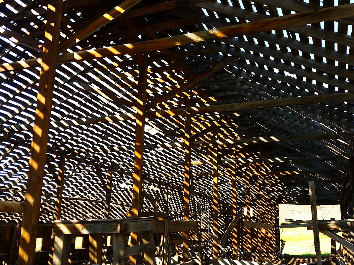
| Twickenham valley barn |
 |
| Priest Hole |
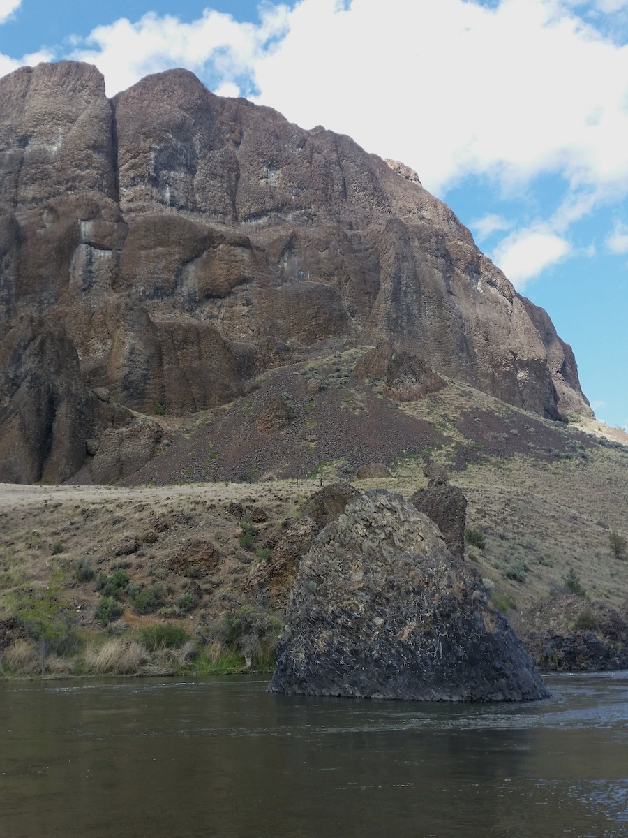 |
| Byrds Point with Vulcans Anvil look alike |
 |
| remnant of Ft. Dalles/Canyon City wagon road |
The wind was cold, but at least it was sunny, so I didn't mind too much. Alas, another day in gore tex pants and jacket.
 |
| camp 5 - Arthur Campbell's "Hungry Rock" |


 |
| these two insisted on waking me up |

Day 6 I stopped to check out an old vacant ranch homestead. I figured it was too cold for big Oregon rattlesnakes to be on the prowl, but I was wrong. Just after I took the photo of the outhouse I noticed a big 6 foot rattler as he crawled under the outhouse. If I'd have included another few inches in the bottom of the photo I'd have inadvertently included it in the photo.
 |
| Lonely Old Ranch |

 |
| 6' rattler just out of view |
 |
| waiting out a rain... |

As I walked back to the boat I saw a river trip coming downstream. I untied my boat, rowed into the current, and met Woody from Portland, who paddled a yellow canoe. They started the day before at Service Creek and were going to Cottonwood Bridge. They wanted to camp in the same area as I planned on, near Cathedral Rock. As it turned out we would see each other, off and on, for the rest of the trip.
After the old ranch I would pass through the nicest camping of this section; mile 122-126. A future trip would require some loitering in this short canyon section.
The wind continued after getting to camp so as a break I went for a short hike up above Cathedral Rock to get a view of Spring Mountain Wilderness. Spring Mountain is one of Oregon's newest wilderness areas, designated in the 2009 omnibus legislation. Also had a nice view back up river into the short canyon section. Later Woody and crew invited me to dinner and I didn't pass up the opportunity for the conversation and especially the fresh green salad.

Ahh, the lower John Day. It strikes me in the soul like nothing else. Not sure why, maybe the older I get the more nostalgic I get about my home dirt.
I knew in advance that the whitewater wouldn't really be a challenge on this trip, but for a couple places. The most notable at Clarno rapid. I thought Soggy Sneakers did a nice job of summarizing this rapid. It says: "...it's long and complicated, so give it a scout". I didn't think it was too big of a deal, as long as you stayed on your line. As anyone can see, the river wide hole near the bottom would suck to go into, especially given the rocky swim below. The top of the tongue wanted to push right at the flow when I was there. Long rapids like this that are scouted from high above can be confusing once your at the oars so it's a fun test of scouting skill. Picking out markers that are recognizable from river level always helps me. Or, dividing the river into halves or thirds until markers are in view helps me too.


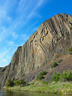
I'm not sure how long ago this debris flow happened, but it's pretty dramatic, in that it constricts the river and pushes hard right into the top of Basalt rapid. I was able to read/run right of center, but at high flows this would exciting.


Basalt Rapid is sort of the beginning of the Great Basalt Gorge. I remember this canyon from the trip in 2009 and wanted to camp in here. The river camps are the best of the trip from mile 93-89.


I was originally planning to stay another day, but the grey sky and gore-tex clothes for the 6th day in a row convinced me to start thinking. I thought about the heater in the blazer, and a cotton t-shirt, and about getting a head start on the drive back to Utah. A meadow lark song echoed high above the river, through the basalt formations. I was sad to think of them singing goodbye. I knew the end was nigh with less than 10 miles to go, yet I still had an eye out for a campsite. Cottonwood bridge came into view at 3pm and I refused to row. The wind went perfectly still, and would offer me the final half mile, as complimentary. The erie grey stillness of the canyon made a passing car seem more shiny than it needed to be. It was going faster than it needed to go, and was too loud. The lustrous pace of the world would throw itself at me whether I rowed or not. I drifted under the bridge and rowed to shore so I wouldn't continue over Tumwater falls. 211 miles, and 9 days by myself were done.
The wind continued after getting to camp so as a break I went for a short hike up above Cathedral Rock to get a view of Spring Mountain Wilderness. Spring Mountain is one of Oregon's newest wilderness areas, designated in the 2009 omnibus legislation. Also had a nice view back up river into the short canyon section. Later Woody and crew invited me to dinner and I didn't pass up the opportunity for the conversation and especially the fresh green salad.
 |
| upstream toward mouth of short cyn section |
 |
| looking towards Spring Mtn. Wilderness |
 |
| Camp 6 |
Clarno to Cottonwood:

Ahh, the lower John Day. It strikes me in the soul like nothing else. Not sure why, maybe the older I get the more nostalgic I get about my home dirt.
I knew in advance that the whitewater wouldn't really be a challenge on this trip, but for a couple places. The most notable at Clarno rapid. I thought Soggy Sneakers did a nice job of summarizing this rapid. It says: "...it's long and complicated, so give it a scout". I didn't think it was too big of a deal, as long as you stayed on your line. As anyone can see, the river wide hole near the bottom would suck to go into, especially given the rocky swim below. The top of the tongue wanted to push right at the flow when I was there. Long rapids like this that are scouted from high above can be confusing once your at the oars so it's a fun test of scouting skill. Picking out markers that are recognizable from river level always helps me. Or, dividing the river into halves or thirds until markers are in view helps me too.


I'm not sure how long ago this debris flow happened, but it's pretty dramatic, in that it constricts the river and pushes hard right into the top of Basalt rapid. I was able to read/run right of center, but at high flows this would exciting.


Basalt Rapid is sort of the beginning of the Great Basalt Gorge. I remember this canyon from the trip in 2009 and wanted to camp in here. The river camps are the best of the trip from mile 93-89.


 |
| camp 7 - Great Basalt Gorge |


 |
| my magic carpet loyally waits... |
 |
| kokopelli tree |

 |
| camp 8 - The Palisades |

I was originally planning to stay another day, but the grey sky and gore-tex clothes for the 6th day in a row convinced me to start thinking. I thought about the heater in the blazer, and a cotton t-shirt, and about getting a head start on the drive back to Utah. A meadow lark song echoed high above the river, through the basalt formations. I was sad to think of them singing goodbye. I knew the end was nigh with less than 10 miles to go, yet I still had an eye out for a campsite. Cottonwood bridge came into view at 3pm and I refused to row. The wind went perfectly still, and would offer me the final half mile, as complimentary. The erie grey stillness of the canyon made a passing car seem more shiny than it needed to be. It was going faster than it needed to go, and was too loud. The lustrous pace of the world would throw itself at me whether I rowed or not. I drifted under the bridge and rowed to shore so I wouldn't continue over Tumwater falls. 211 miles, and 9 days by myself were done.
 |
| catboat 1041 at the end |
Damn. Great stuff, Mick. Hope I can meet Iris someday under similar circumstances. And your final paragraph captures the experience of river running perfectly. Thanks for the joy. - Craig
ReplyDelete